
Snow Will Pile Up As Nor’easter Targets Maine On Tuesday
It was a January to forget in Maine for snow lovers. A significant portion of the state saw well-below-average snowfall amounts and temperatures that also were far above-normal. That amounted to snowmobilers and skiers alike sweating the idea of the winter not living up to expectations. While January may have been forgettable for snow, February is set to arrive in style, with Maine's first full-blown Nor'easter since November arriving late on Monday night.
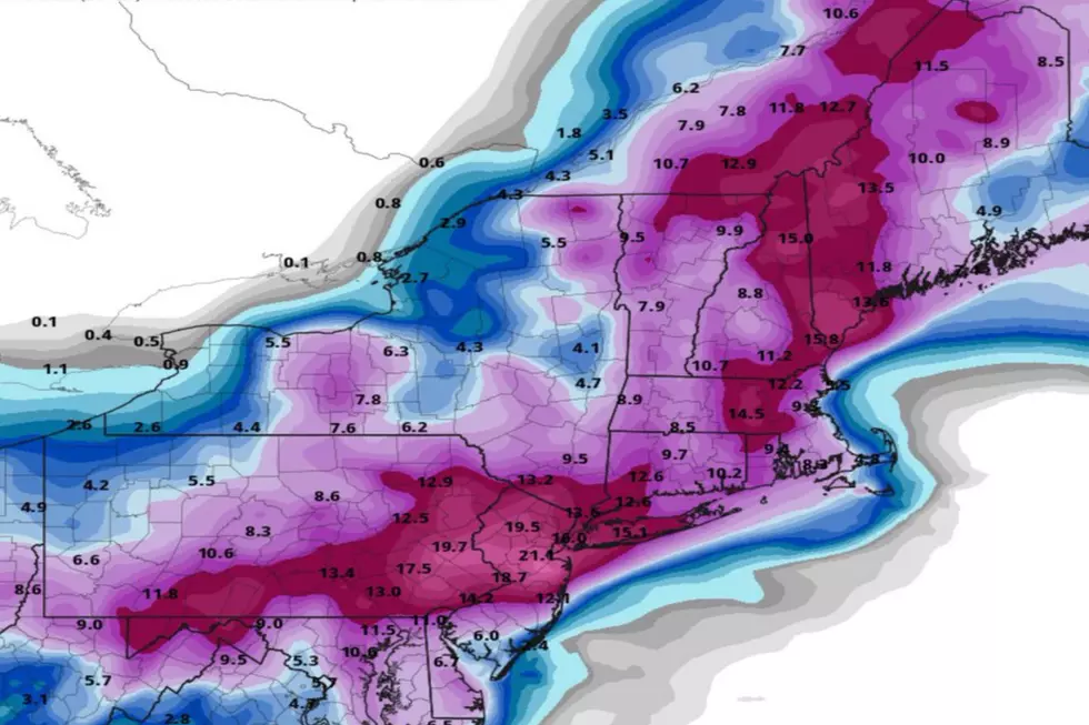
Shared on Twitter by Robert LaRoche, for a large portion of the state, the Nor'easter will bring some serious snowfall amounts. Western Maine could see totals amounting close to two feet, with much of the rest of southern and central Maine seeing anywhere from 10-16 inches. The surprising "losers" of this particular storm are northern and eastern Maine. Typically, those two areas of the state are a bonanza for snowfall amounts, but for this particularly storm, they won't be hitting the jackpot. Here's another snowfall map shared on Twitter by Mike Slifer.
The Nor'easter is set to crawl over Maine starting very late Monday night. The storm should be an all-day event on Tuesday and will likely wrap up sometime overnight Tuesday or early Wednesday morning. As with any Nor'easter, wind will be an issue. Gusts are expected to be powerful, although not to the lengths we've seen with other recent storms that have caused major, widespread power outages. That is good news for everyone that lives in Maine.
So whether or not the groundhog see his shadow is inconsequential to us, winter will be in session on Tuesday. Hope you didn't put those shovels away yet.
KEEP READING: Get answers to 51 of the most frequently asked weather questions...
More From 94.3 WCYY